
Make a donation
Gear up for your next adventure:
As an Amazon Associate, this site earns from qualifying purchases at no extra cost to you.
Misty River topographic map
Click on the map to display elevation.
Make a donation
Gear up for your next adventure:
As an Amazon Associate, this site earns from qualifying purchases at no extra cost to you.
About this map
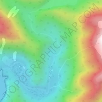
Name: Misty River topographic map, elevation, terrain.
Average elevation: 1,240 ft
Minimum elevation: 0 ft
Maximum elevation: 3,615 ft
Make a donation
Gear up for your next adventure:
As an Amazon Associate, this site earns from qualifying purchases at no extra cost to you.
Other topographic maps
Click on a map to view its topography, its elevation and its terrain.
Whitewater River
New Zealand > Southland > Southland District > Fiordland Community
Average elevation: 1,808 ft
Sutherland Falls
New Zealand > Southland > Southland District > Fiordland Community
Average elevation: 3,301 ft
Mount Mackenzie
New Zealand > Southland > Southland District > Fiordland Community
Average elevation: 3,839 ft
Make a donation
Gear up for your next adventure:
As an Amazon Associate, this site earns from qualifying purchases at no extra cost to you.
Milford Sound
New Zealand > Southland > Southland District > Fiordland Community
Average elevation: 2,149 ft
Manapouri
New Zealand > Southland > Southland District > Fiordland Community > Manapouri
Average elevation: 699 ft
Turner Falls
New Zealand > Southland > Southland District > Fiordland Community
Average elevation: 4,380 ft