
Bovingdon topographic map
Click on the map to display elevation.
About this map
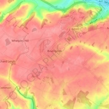
Name: Bovingdon topographic map, elevation, terrain.
Location: Bovingdon, Dacorum, Hertfordshire, England, United Kingdom (51.69930 -0.56561 51.74457 -0.49225)
Average elevation: 482 ft
Minimum elevation: 282 ft
Maximum elevation: 548 ft
Other topographic maps
Click on a map to view its topography, its elevation and its terrain.
Little Heath
United Kingdom > England > Hertfordshire > Dacorum > Potten End
Average elevation: 453 ft
Long Marston
United Kingdom > England > Hertfordshire > Dacorum > Long Marston
Average elevation: 302 ft
Saint Margarets Copse
United Kingdom > England > Hertfordshire > Dacorum > Great Gaddesden
Average elevation: 472 ft
Hammerfield
United Kingdom > England > Hertfordshire > Dacorum > Hemel Hempstead
Average elevation: 400 ft
Tringford Reservoir
United Kingdom > England > Hertfordshire > Dacorum > Tring > Wilstone
Average elevation: 390 ft
Dixon's Gap Bridge
United Kingdom > England > Hertfordshire > Dacorum > Wilstone > Gubblecote
Average elevation: 331 ft
Westbrook Mere
United Kingdom > England > Hertfordshire > Dacorum > Bourne End
Average elevation: 410 ft
Trowley Bottom
United Kingdom > England > Hertfordshire > Dacorum > Flamstead
Average elevation: 456 ft
Nettleden
United Kingdom > England > Hertfordshire > Dacorum > Great Gaddesden
Average elevation: 489 ft
Bovingdon Green
United Kingdom > England > Hertfordshire > Dacorum > Bovingdon
Average elevation: 495 ft
Frithsden Beeches
United Kingdom > England > Hertfordshire > Dacorum > Potten End
Average elevation: 525 ft