
Basingstoke topographic map
Click on the map to display elevation.
Basingstoke
Situated in a valley through the Hampshire Downs at an average elevation of 88 metres (289 ft) Basingstoke is a major interchange between Reading, Newbury, Andover, Winchester, and Alton, and lies on the natural trade route between the southwest of England and London. The area had been something of an interchange even in ancient times. It had been cut by a Roman roadway that ran from northeast to southwest, from Silchester towards Salisbury (Sorbiodunum), and by another Roman road that linked Silchester (Calleva Atrebatum) in the north with Winchester (Venta Belgarum) to the south. These cross-cutting highways, along with the good agricultural land hereabouts, account for the many "Roman" villas in the area, mostly put up by Romanized native nobility (Roman villa). Even more ancient was the Harrow Way, a Neolithic trackway, possibly associated with the ancient tin trade, that crossed all of southern England from west to east, from Cornwall to Kent, passing right through Andover and Basingstoke.
About this map
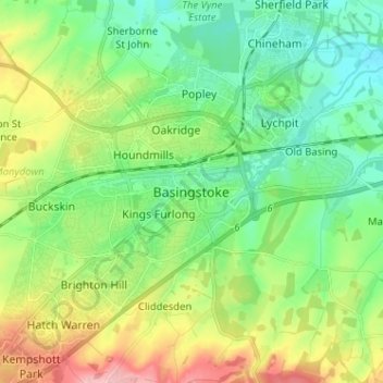
Name: Basingstoke topographic map, elevation, terrain.
Average elevation: 351 ft
Minimum elevation: 194 ft
Maximum elevation: 676 ft
Other topographic maps
Click on a map to view its topography, its elevation and its terrain.
Morgaston Wood
United Kingdom > England > Hampshire > Basingstoke and Deane > Sherborne St John
Average elevation: 249 ft
Winterhill Plantation
United Kingdom > England > Hampshire > Basingstoke and Deane > Whitchurch > Wells-In-The-Field
Average elevation: 328 ft
Basingstoke
United Kingdom > England > Hampshire > Basingstoke and Deane
Situated in a valley through the Hampshire Downs at an average elevation of 88 metres (289 ft) Basingstoke is a major interchange between Reading, Newbury, Andover, Winchester, and Alton, and lies on the natural trade route between the southwest of England and London. The area had been something of an…
Average elevation: 358 ft
Highclere Castle
United Kingdom > England > Hampshire > Basingstoke and Deane
Average elevation: 545 ft
Mortimer West End
United Kingdom > England > Hampshire > Basingstoke and Deane > Mortimer West End
Average elevation: 295 ft
Wootton St. Lawrence
United Kingdom > England > Hampshire > Basingstoke and Deane
Average elevation: 377 ft
Newtown
United Kingdom > England > Hampshire > Basingstoke and Deane > Newtown
Average elevation: 358 ft
Sherborne St. John
United Kingdom > England > Hampshire > Basingstoke and Deane > Sherborne St John
Average elevation: 259 ft
Bramley Corner
United Kingdom > England > Hampshire > Basingstoke and Deane > Bramley
Average elevation: 226 ft
Windabout Copse
United Kingdom > England > Hampshire > Basingstoke and Deane
Average elevation: 262 ft
Sherfield on Loddon
United Kingdom > England > Hampshire > Basingstoke and Deane
Average elevation: 217 ft
Monk Sherborne
United Kingdom > England > Hampshire > Basingstoke and Deane > Monk Sherborne
Average elevation: 351 ft
Kingsclere
United Kingdom > England > Hampshire > Basingstoke and Deane > Kingsclere
Average elevation: 456 ft
Chineham
United Kingdom > England > Hampshire > Basingstoke and Deane > Basingstoke
Average elevation: 256 ft
River Lyde
United Kingdom > England > Hampshire > Basingstoke and Deane > Up Nately
Average elevation: 256 ft
Hartley Wespall
United Kingdom > England > Hampshire > Basingstoke and Deane
Average elevation: 223 ft
Baughurst
United Kingdom > England > Hampshire > Basingstoke and Deane > Wolverton Townsend
Average elevation: 348 ft
St. Mary Bourne
United Kingdom > England > Hampshire > Basingstoke and Deane > Stoke
Average elevation: 410 ft
East Woodhay
United Kingdom > England > Hampshire > Basingstoke and Deane > East End
Average elevation: 561 ft
Wootton St. Lawrence
United Kingdom > England > Hampshire > Basingstoke and Deane
Average elevation: 377 ft
Preston Candover
United Kingdom > England > Hampshire > Basingstoke and Deane
Average elevation: 427 ft
Chineham
United Kingdom > England > Hampshire > Basingstoke and Deane > Basingstoke
Average elevation: 256 ft
Highclere
United Kingdom > England > Hampshire > Basingstoke and Deane > Highclere
Average elevation: 505 ft
Highclere
United Kingdom > England > Hampshire > Basingstoke and Deane > Highclere
Average elevation: 505 ft