
Windabout Copse topographic map
Click on the map to display elevation.
About this map
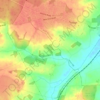
Name: Windabout Copse topographic map, elevation, terrain.
Average elevation: 262 ft
Minimum elevation: 167 ft
Maximum elevation: 328 ft
Other topographic maps
Click on a map to view its topography, its elevation and its terrain.
Sherborne St John
United Kingdom > England > Hampshire > Basingstoke and Deane
Average elevation: 302 ft
Mortimer West End
United Kingdom > England > Hampshire > Basingstoke and Deane > Mortimer West End
Average elevation: 295 ft
Basingstoke
United Kingdom > England > Hampshire > Basingstoke and Deane
Situated in a valley through the Hampshire Downs at an average elevation of 88 metres (289 ft) Basingstoke is a major interchange between Reading, Newbury, Andover, Winchester, and Alton, and lies on the natural trade route between the southwest of England and London. The area had been something of an…
Average elevation: 351 ft
Wootton St. Lawrence
United Kingdom > England > Hampshire > Basingstoke and Deane
Average elevation: 377 ft
Newtown
United Kingdom > England > Hampshire > Basingstoke and Deane > Newtown
Average elevation: 358 ft
Sherborne St. John
United Kingdom > England > Hampshire > Basingstoke and Deane > Sherborne St John
Average elevation: 259 ft
Sherfield on Loddon
United Kingdom > England > Hampshire > Basingstoke and Deane
Average elevation: 217 ft
Wolverton Common
United Kingdom > England > Hampshire > Basingstoke and Deane
Average elevation: 325 ft
Pamber Green
United Kingdom > England > Hampshire > Basingstoke and Deane > Tadley
Average elevation: 279 ft
Monk Sherborne
United Kingdom > England > Hampshire > Basingstoke and Deane > Monk Sherborne
Average elevation: 351 ft
Wolverton Townsend
United Kingdom > England > Hampshire > Basingstoke and Deane
Average elevation: 348 ft
Kingsclere
United Kingdom > England > Hampshire > Basingstoke and Deane > Kingsclere
Average elevation: 456 ft
Chineham
United Kingdom > England > Hampshire > Basingstoke and Deane > Basingstoke
Average elevation: 256 ft
Cufaude
United Kingdom > England > Hampshire > Basingstoke and Deane > Bramley
Average elevation: 226 ft
Hartley Wespall
United Kingdom > England > Hampshire > Basingstoke and Deane
Average elevation: 223 ft
Baughurst
United Kingdom > England > Hampshire > Basingstoke and Deane > Wolverton Townsend
Average elevation: 348 ft
Cole Henley
United Kingdom > England > Hampshire > Basingstoke and Deane > Whitchurch
Average elevation: 387 ft
Latchmere Green
United Kingdom > England > Hampshire > Basingstoke and Deane > Little London > Latchmere Green
Average elevation: 240 ft
St. Mary Bourne
United Kingdom > England > Hampshire > Basingstoke and Deane > Stoke
Average elevation: 410 ft
East Woodhay
United Kingdom > England > Hampshire > Basingstoke and Deane > East End
Average elevation: 561 ft
Chilton Candover
United Kingdom > England > Hampshire > Basingstoke and Deane > Chilton Candover
Average elevation: 387 ft
Tufton
United Kingdom > England > Hampshire > Basingstoke and Deane > Hurstbourne Priors
Average elevation: 285 ft
Ellisfield Green
United Kingdom > England > Hampshire > Basingstoke and Deane > Ellisfield
Average elevation: 574 ft
Bidden
United Kingdom > England > Hampshire > Basingstoke and Deane > Upton Grey
Average elevation: 351 ft
Heath End
United Kingdom > England > Hampshire > Basingstoke and Deane > East End > Heath End
Average elevation: 472 ft
Wootton St. Lawrence
United Kingdom > England > Hampshire > Basingstoke and Deane
Average elevation: 377 ft
Preston Candover
United Kingdom > England > Hampshire > Basingstoke and Deane
Average elevation: 427 ft
Basingstoke
United Kingdom > England > Hampshire > Basingstoke and Deane
Situated in a valley through the Hampshire Downs at an average elevation of 88 metres (289 ft), Basingstoke is a major interchange between Reading, Newbury, Andover, Winchester and Alton. It lies on the natural trade route between the south-west of England and London. The area had been something of an…
Average elevation: 351 ft
Chineham
United Kingdom > England > Hampshire > Basingstoke and Deane > Basingstoke
Average elevation: 256 ft
Highclere
United Kingdom > England > Hampshire > Basingstoke and Deane > Highclere
Average elevation: 505 ft
Basingstoke
United Kingdom > England > Hampshire > Basingstoke and Deane
Situated in a valley through the Hampshire Downs at an average elevation of 88 metres (289 ft) Basingstoke is a major interchange between Reading, Newbury, Andover, Winchester, and Alton, and lies on the natural trade route between the southwest of England and London. The area had been something of an…
Average elevation: 351 ft
Highclere
United Kingdom > England > Hampshire > Basingstoke and Deane > Highclere
Average elevation: 505 ft