Geolocate

Jasper topographic map

Click on the map to display elevation.

About this map

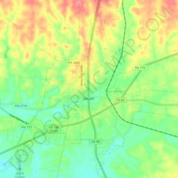
Name: Jasper topographic map, elevation, terrain.

Location: Jasper, Jasper County, Texas, 75951, United States (30.88217 -94.03656 30.96669 -93.94715)

Average elevation: 253 ft

Minimum elevation: 144 ft

Maximum elevation: 397 ft

Jasper County trails, hiking, mountain biking, running and outdoor activities

Other topographic maps

Click on a map to view its topography, its elevation and its terrain.

Buna

United States > Texas > Jasper County

Average elevation: 79 ft

Blue Hole

United States > Texas > Jasper County

Average elevation: 135 ft

Gear up for your next adventure:

🧥Waterproof Jacket for Hiking - Breathable and rugged rain jacket for outdoor excursions
🧤Tactile Hiking Gloves - Keep hands warm while operating GPS and smartphone screens
🚗GPS Dash Cams - Record your scenic drives through mountain passes and canyons
🔭Telescopic Hiking Pole - Adjustable pole for hiking stability
🥾Women's Hiking Boots - Top-rated trail boots with ankle support and superior grip

As an Amazon Associate, this site earns from qualifying purchases at no extra cost to you.