
Make a donation
Gear up for your next adventure:
As an Amazon Associate, this site earns from qualifying purchases at no extra cost to you.
Halle (Saale) topographic map
Click on the map to display elevation.
Make a donation
Gear up for your next adventure:
As an Amazon Associate, this site earns from qualifying purchases at no extra cost to you.
About this map
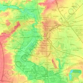
Name: Halle (Saale) topographic map, elevation, terrain.
Location: Halle (Saale), Saxony-Anhalt, Germany (51.40210 11.85525 51.54351 12.08922)
Average elevation: 328 ft
Minimum elevation: 194 ft
Maximum elevation: 472 ft
Make a donation
Gear up for your next adventure:
As an Amazon Associate, this site earns from qualifying purchases at no extra cost to you.
Other topographic maps
Click on a map to view its topography, its elevation and its terrain.
Dessau
Germany > Saxony-Anhalt > Dessau-Roßlau
Dessau is situated on a floodplain where the Mulde flows into the Elbe. This causes yearly floods. The worst flood took place in the year 2002, when the Waldersee district was nearly completely flooded. The south of Dessau touches a well-wooded area called Mosigkauer Heide. The highest elevation is a 110 m…
Average elevation: 203 ft
Brocken
Germany > Saxony-Anhalt > Landkreis Harz > Wernigerode
The Brocken (German pronunciation: [ˈbʁɔkn̩] ), also sometimes referred to as the Blocksberg, is a 1,141 m (3,743 ft) mountain near Schierke in the German state of Saxony-Anhalt, between the rivers Weser and Elbe. The highest peak in the Harz mountain range, and in Northern Germany, it is subalpine, yet…
Average elevation: 3,159 ft
Make a donation
Gear up for your next adventure:
As an Amazon Associate, this site earns from qualifying purchases at no extra cost to you.
Dessau
Germany > Saxony-Anhalt > Dessau-Roßlau
Dessau is situated on a floodplain where the Mulde flows into the Elbe. This causes yearly floods. The worst flood took place in the year 2002, when the Waldersee district was nearly completely flooded. The south of Dessau touches a well-wooded area called Mosigkauer Heide. The highest elevation is a 110 m…
Average elevation: 203 ft
Make a donation
Gear up for your next adventure:
As an Amazon Associate, this site earns from qualifying purchases at no extra cost to you.
Make a donation
Gear up for your next adventure:
As an Amazon Associate, this site earns from qualifying purchases at no extra cost to you.
Make a donation
Gear up for your next adventure:
As an Amazon Associate, this site earns from qualifying purchases at no extra cost to you.
Tromsdorf
Germany > Saxony-Anhalt > Burgenlandkreis > Eckartsberga > Tromsdorf
Average elevation: 640 ft
Make a donation
Gear up for your next adventure:
As an Amazon Associate, this site earns from qualifying purchases at no extra cost to you.
Aschersleben
Germany > Saxony-Anhalt > Salzlandkreis > Aschersleben > Aschersleben
Average elevation: 456 ft
Make a donation
Gear up for your next adventure:
As an Amazon Associate, this site earns from qualifying purchases at no extra cost to you.