
Make a donation
Gear up for your next adventure:
As an Amazon Associate, this site earns from qualifying purchases at no extra cost to you.
Cerro Santa Lucía topographic map
Click on the map to display elevation.
Make a donation
Gear up for your next adventure:
As an Amazon Associate, this site earns from qualifying purchases at no extra cost to you.
Cerro Santa Lucía
El cerro Santa Lucía, antiguamente llamado cerro Huelén en picunche, es un parque urbano ubicado en el corazón de la ciudad de Santiago de Chile. Limita al sur con la Avenida Libertador General Bernardo O'Higgins, donde se encuentra la estación Santa Lucía del Metro de Santiago, al oeste con la calle Santa Lucía, al norte con la calle Merced y al este con la calle Victoria Subercaseaux. Tiene una altitud de 629 m s. n. m., una altura de 68 m y una superficie de 65300 m².
Make a donation
Gear up for your next adventure:
As an Amazon Associate, this site earns from qualifying purchases at no extra cost to you.
About this map
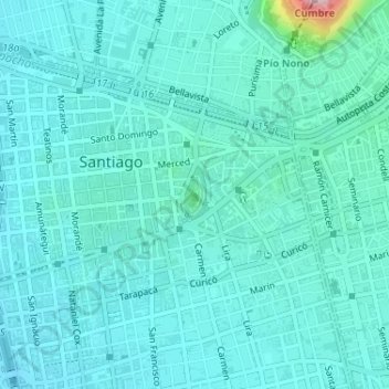
Name: Cerro Santa Lucía topographic map, elevation, terrain.
Average elevation: 1,880 ft
Minimum elevation: 1,768 ft
Maximum elevation: 2,697 ft
Make a donation
Gear up for your next adventure:
As an Amazon Associate, this site earns from qualifying purchases at no extra cost to you.
Other topographic maps
Click on a map to view its topography, its elevation and its terrain.
La Reina
Chile > Región Metropolitana de Santiago > Provincia de Santiago > Santiago
Average elevation: 2,835 ft
Recoleta
Chile > Región Metropolitana de Santiago > Provincia de Santiago > Santiago
Average elevation: 1,883 ft
San Miguel
Chile > Región Metropolitana de Santiago > Provincia de Santiago > Santiago
Average elevation: 1,798 ft
Palacio de La Moneda
Chile > Región Metropolitana de Santiago > Provincia de Santiago > Santiago
Average elevation: 1,831 ft
Make a donation
Gear up for your next adventure:
As an Amazon Associate, this site earns from qualifying purchases at no extra cost to you.
Maipú
Chile > Región Metropolitana de Santiago > Provincia de Santiago > Santiago
Inaugurado el 13 de septiembre de 1910, este es el único monumento que responde a una orden directa de Bernardo O'Higgins. En la Gaceta Ministerial n.º 44 del sábado 13 de junio de 1818, O'Higgins y Zenteno decretaron: "En lo más descubierto de la loma, teatro principal de la batalla y de nuestros…
Average elevation: 1,654 ft
Las Condes
Chile > Región Metropolitana de Santiago > Provincia de Santiago > Santiago
Average elevation: 2,572 ft
Recoleta
Chile > Región Metropolitana de Santiago > Provincia de Santiago > Santiago
Average elevation: 1,824 ft
La Florida
Chile > Región Metropolitana de Santiago > Provincia de Santiago > Santiago
Average elevation: 2,129 ft
Make a donation
Gear up for your next adventure:
As an Amazon Associate, this site earns from qualifying purchases at no extra cost to you.
El Bosque
Chile > Región Metropolitana de Santiago > Provincia de Santiago > Santiago
Average elevation: 1,923 ft
Parque Forestal
Chile > Región Metropolitana de Santiago > Provincia de Santiago > Santiago
Average elevation: 1,926 ft
Recoleta
Chile > Región Metropolitana de Santiago > Provincia de Santiago > Santiago
Average elevation: 1,824 ft
Lo Espejo
Chile > Región Metropolitana de Santiago > Provincia de Santiago > Santiago
Average elevation: 1,759 ft
Make a donation
Gear up for your next adventure:
As an Amazon Associate, this site earns from qualifying purchases at no extra cost to you.