
Make a donation
Gear up for your next adventure:
As an Amazon Associate, this site earns from qualifying purchases at no extra cost to you.
La Florida topographic map
Click on the map to display elevation.
Make a donation
Gear up for your next adventure:
As an Amazon Associate, this site earns from qualifying purchases at no extra cost to you.
About this map
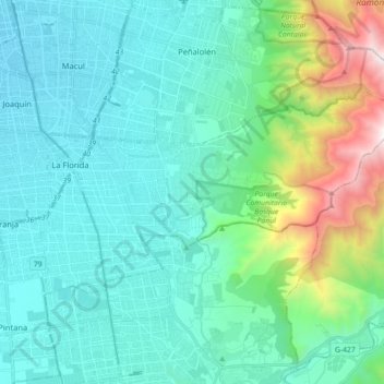
Name: La Florida topographic map, elevation, terrain.
Average elevation: 2,129 ft
Minimum elevation: 1,677 ft
Maximum elevation: 4,554 ft
Make a donation
Gear up for your next adventure:
As an Amazon Associate, this site earns from qualifying purchases at no extra cost to you.
Other topographic maps
Click on a map to view its topography, its elevation and its terrain.
Parque O'Higgins
Chile > Región Metropolitana de Santiago > Provincia de Santiago > Santiago
Average elevation: 1,759 ft
Parque San Borja
Chile > Región Metropolitana de Santiago > Provincia de Santiago > Santiago
Average elevation: 1,896 ft
Plaza Panamá
Chile > Región Metropolitana de Santiago > Provincia de Santiago > Santiago
Average elevation: 1,785 ft
Parque Forestal
Chile > Región Metropolitana de Santiago > Provincia de Santiago > Santiago
Average elevation: 1,916 ft
Make a donation
Gear up for your next adventure:
As an Amazon Associate, this site earns from qualifying purchases at no extra cost to you.
Plaza Los Presidentes
Chile > Región Metropolitana de Santiago > Provincia de Santiago > Santiago
Average elevation: 1,962 ft
Parque de los Reyes
Chile > Región Metropolitana de Santiago > Provincia de Santiago > Santiago
Average elevation: 1,765 ft
Parque Santa Rosa de Apoquindo
Chile > Región Metropolitana de Santiago > Provincia de Santiago > Santiago
Average elevation: 2,385 ft
Cerro Santa Lucía
Chile > Región Metropolitana de Santiago > Provincia de Santiago > Santiago
El cerro Santa Lucía, antiguamente llamado cerro Huelén en picunche, es un parque urbano ubicado en el corazón de la ciudad de Santiago de Chile. Limita al sur con la Avenida Libertador General Bernardo O'Higgins, donde se encuentra la estación Santa Lucía del Metro de Santiago, al oeste con la calle…
Average elevation: 1,880 ft
Make a donation
Gear up for your next adventure:
As an Amazon Associate, this site earns from qualifying purchases at no extra cost to you.
Parque La Quebrada de Macul
Chile > Región Metropolitana de Santiago > Provincia de Santiago > Santiago
Average elevation: 2,247 ft
Parque San Borja
Chile > Región Metropolitana de Santiago > Provincia de Santiago > Santiago
Average elevation: 1,896 ft
Plaza Vicuña Mackenna
Chile > Región Metropolitana de Santiago > Provincia de Santiago > Santiago
Average elevation: 1,867 ft
Parque San Borja
Chile > Región Metropolitana de Santiago > Provincia de Santiago > Santiago
Average elevation: 1,896 ft
Make a donation
Gear up for your next adventure:
As an Amazon Associate, this site earns from qualifying purchases at no extra cost to you.
Parque San Borja
Chile > Región Metropolitana de Santiago > Provincia de Santiago > Santiago
Average elevation: 1,896 ft