Geolocate

Red Rocks Park topographic map

Click on the map to display elevation.

About this map

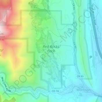
Name: Red Rocks Park topographic map, elevation, terrain.

Location: Red Rocks Park, Golden, Jefferson County, Colorado, United States (39.65306 -105.22184 39.67463 -105.19394)

Average elevation: 6,296 ft

Minimum elevation: 5,745 ft

Maximum elevation: 7,841 ft

Jefferson County trails, hiking, mountain biking, running and outdoor activities

Other topographic maps

Click on a map to view its topography, its elevation and its terrain.

Golden

United States > Colorado > Jefferson County > Golden > Golden

Average elevation: 6,640 ft

Golden

United States > Colorado > Jefferson County > Golden > Golden

Average elevation: 6,352 ft

Gear up for your next adventure:

🎒Day Hiking Backpack - Lightweight backpack perfect for day trips and outdoor adventures
🔦Compact Flashlight - Reliable flashlight for emergencies
🔦LED Headlamp - Bright and durable LED headlamp for night navigation
🛡️Insect Repellent - Protection against bugs during outdoor activities
🧭Outdoor Navigation Book - Learn advanced navigation skills

As an Amazon Associate, this site earns from qualifying purchases at no extra cost to you.