
Lower Burrell topographic map
Click on the map to display elevation.
About this map
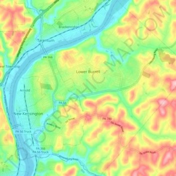
Name: Lower Burrell topographic map, elevation, terrain.
Average elevation: 971 ft
Minimum elevation: 735 ft
Maximum elevation: 1,339 ft
Westmoreland County trails, hiking, mountain biking, running and outdoor activities
Other topographic maps
Click on a map to view its topography, its elevation and its terrain.
Armbrust
United States > Pennsylvania > Westmoreland County > Hempfield Township
Average elevation: 1,083 ft
Circleville
United States > Pennsylvania > Westmoreland County > North Huntingdon Township
Average elevation: 1,093 ft
Donegal Lake
United States > Pennsylvania > Westmoreland County > Donegal Township
Average elevation: 1,617 ft
Bessemer
United States > Pennsylvania > Westmoreland County > East Huntingdon Township
Average elevation: 1,122 ft
Acme
United States > Pennsylvania > Westmoreland County > Mount Pleasant Township
Average elevation: 1,919 ft
Stahlstown
United States > Pennsylvania > Westmoreland County > Cook Township
Average elevation: 1,686 ft
Southwest
United States > Pennsylvania > Westmoreland County > Mount Pleasant Township
Average elevation: 1,102 ft
Twin Lakes Park
United States > Pennsylvania > Westmoreland County > Hempfield Township > Luxor > Georges Station
Average elevation: 1,204 ft
West Export
United States > Pennsylvania > Westmoreland County > Murrysville
Average elevation: 1,119 ft
Kecksburg
United States > Pennsylvania > Westmoreland County > Mount Pleasant Township
Average elevation: 1,325 ft
Newlonsburg
United States > Pennsylvania > Westmoreland County > Murrysville
Average elevation: 1,112 ft
Bell Point
United States > Pennsylvania > Westmoreland County > Bell Township
Average elevation: 1,181 ft
Southwest
United States > Pennsylvania > Westmoreland County > Mount Pleasant Township
Average elevation: 1,102 ft
Chestnut Ridge
United States > Pennsylvania > Westmoreland County > Fairfield Township
Average elevation: 1,529 ft
Tarrs
United States > Pennsylvania > Westmoreland County > East Huntingdon Township
Average elevation: 1,168 ft
Millwood
United States > Pennsylvania > Westmoreland County > Derry Township
Average elevation: 1,335 ft
Buckeye
United States > Pennsylvania > Westmoreland County > East Huntingdon Township
Average elevation: 1,109 ft
Turkeytown
United States > Pennsylvania > Westmoreland County > South Huntingdon Township
Average elevation: 1,040 ft
Perryville
United States > Pennsylvania > Westmoreland County > Bell Township
Average elevation: 1,198 ft
Morewood
United States > Pennsylvania > Westmoreland County > East Huntingdon Township
Average elevation: 1,171 ft
Painter Rock Hill
United States > Pennsylvania > Westmoreland County > Donegal Township
Average elevation: 2,562 ft
Alverton
United States > Pennsylvania > Westmoreland County > East Huntingdon Township
Average elevation: 1,184 ft
United
United States > Pennsylvania > Westmoreland County > Mount Pleasant Township
Average elevation: 1,070 ft
Collinsburg
United States > Pennsylvania > Westmoreland County > Rostraver Township
Average elevation: 925 ft
Maplewood Terrace
United States > Pennsylvania > Westmoreland County > Hempfield Township > Maplewood Terrace
Average elevation: 1,135 ft
Bessemer
United States > Pennsylvania > Westmoreland County > East Huntingdon Township > Bessemer
Average elevation: 1,122 ft