Geolocate

Englee topographic map

Click on the map to display elevation.

About this map

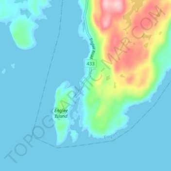
Name: Englee topographic map, elevation, terrain.

Location: Englee, Newfoundland, Newfoundland and Labrador, Canada (50.71369 -56.12357 50.75369 -56.08357)

Average elevation: 112 ft

Minimum elevation: -7 ft

Maximum elevation: 646 ft

Gear up for your next adventure:

🩹Survival Bandages - High‑quality bandages for emergencies
🗻Climbing Gear Basics - Essential gear for beginner climbers
🧴Hand Sanitizer - Keep hands clean while hiking
🍳Camping Cook Set - Complete cookware for outdoor meals
🥘Titanium Cookware - Durable, featherlight pots and pans for backpacking

As an Amazon Associate, this site earns from qualifying purchases at no extra cost to you.