Geolocate

Tiffin Basin topographic map

Click on the map to display elevation.

About this map

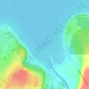
Name: Tiffin Basin topographic map, elevation, terrain.

Location: Tiffin Basin, Tay, Simcoe County, Central Ontario, Ontario, L4R 0E7, Canada (44.75289 -79.85684 44.75299 -79.85674)

Average elevation: 620 ft

Minimum elevation: 574 ft

Maximum elevation: 778 ft

Other topographic maps

Click on a map to view its topography, its elevation and its terrain.

Gear up for your next adventure:

🦶Carbon Trekking Poles - Reduce knee impact on steep descents with ultra-light poles
🌎3D Topographic Globes - Raised relief globes for a tactile understanding of geography
❄️Traction Cleats - Prevent slips on icy trails during winter hikes
🗃️Trail First Aid Kit - Essential kit for outdoor injuries and emergencies
⛑️Personal Locator Beacon - Safety beacon for emergencies

As an Amazon Associate, this site earns from qualifying purchases at no extra cost to you.