
Make a donation
Gear up for your next adventure:
As an Amazon Associate, this site earns from qualifying purchases at no extra cost to you.
Denby CP topographic map
Click on the map to display elevation.
Make a donation
Gear up for your next adventure:
As an Amazon Associate, this site earns from qualifying purchases at no extra cost to you.
About this map
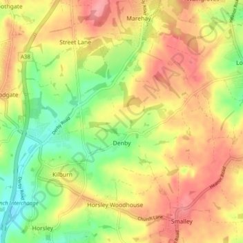
Name: Denby CP topographic map, elevation, terrain.
Location: Denby CP, Amber Valley, Derbyshire, England, United Kingdom (53.00033 -1.45321 53.03293 -1.37608)
Average elevation: 374 ft
Minimum elevation: 213 ft
Maximum elevation: 512 ft
Make a donation
Gear up for your next adventure:
As an Amazon Associate, this site earns from qualifying purchases at no extra cost to you.
Other topographic maps
Click on a map to view its topography, its elevation and its terrain.
Alfreton Park
United Kingdom > England > Derbyshire > Amber Valley > Alfreton CP > Oakerthorpe
Average elevation: 381 ft
Sawmills
United Kingdom > England > Derbyshire > Amber Valley > Ripley > Fritchley
Average elevation: 390 ft
Make a donation
Gear up for your next adventure:
As an Amazon Associate, this site earns from qualifying purchases at no extra cost to you.