
Make a donation
Gear up for your next adventure:
As an Amazon Associate, this site earns from qualifying purchases at no extra cost to you.
Dettighofen topographic map
Click on the map to display elevation.
Make a donation
Gear up for your next adventure:
As an Amazon Associate, this site earns from qualifying purchases at no extra cost to you.
About this map
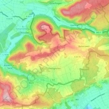
Name: Dettighofen topographic map, elevation, terrain.
Average elevation: 1,644 ft
Minimum elevation: 1,204 ft
Maximum elevation: 2,221 ft
Make a donation
Gear up for your next adventure:
As an Amazon Associate, this site earns from qualifying purchases at no extra cost to you.
Other topographic maps
Click on a map to view its topography, its elevation and its terrain.
Binzgen
Deutschland > Baden-Württemberg > Landkreis Waldshut > Laufenburg (Baden)
Average elevation: 1,339 ft
Gurtweil
Deutschland > Baden-Württemberg > Landkreis Waldshut
Gurtweil liegt im Südschwarzwald am Unterlauf der Schlücht auf einer Höhe von ca. 372 m. ü. NN. Die Gemarkung Gurtweil erstreckt sich von Norden nach Süden über die letzten etwa 4 km des sich weitenden Schlüchttals und von Osten nach Westen bis auf die Höhen der benachbarten Bergrücken des Neuberges…
Average elevation: 1,496 ft
Make a donation
Gear up for your next adventure:
As an Amazon Associate, this site earns from qualifying purchases at no extra cost to you.
Make a donation
Gear up for your next adventure:
As an Amazon Associate, this site earns from qualifying purchases at no extra cost to you.
Dachsberg (Südschwarzwald)
Deutschland > Baden-Württemberg > Landkreis Waldshut
Average elevation: 2,595 ft
Make a donation
Gear up for your next adventure:
As an Amazon Associate, this site earns from qualifying purchases at no extra cost to you.
Menzenschwand-Vorderdorf
Deutschland > Baden-Württemberg > Landkreis Waldshut > St. Blasien
Average elevation: 3,474 ft
Schweikhof
Deutschland > Baden-Württemberg > Landkreis Waldshut > Willaringen
Average elevation: 2,234 ft
Make a donation
Gear up for your next adventure:
As an Amazon Associate, this site earns from qualifying purchases at no extra cost to you.
Prestenberg
Deutschland > Baden-Württemberg > Landkreis Waldshut > Todtmoos
Average elevation: 3,419 ft