
Make a donation
Gear up for your next adventure:
As an Amazon Associate, this site earns from qualifying purchases at no extra cost to you.
Caudete topographic map
Click on the map to display elevation.
Make a donation
Gear up for your next adventure:
As an Amazon Associate, this site earns from qualifying purchases at no extra cost to you.
About this map
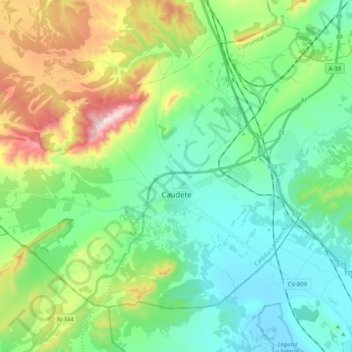
Name: Caudete topographic map, elevation, terrain.
Location: Caudete, Albacete, Castile-La Mancha, 02660, Spain (38.65507 -1.11967 38.77479 -0.91579)
Average elevation: 2,188 ft
Minimum elevation: 1,601 ft
Maximum elevation: 3,750 ft
Make a donation
Gear up for your next adventure:
As an Amazon Associate, this site earns from qualifying purchases at no extra cost to you.
Other topographic maps
Click on a map to view its topography, its elevation and its terrain.
Make a donation
Gear up for your next adventure:
As an Amazon Associate, this site earns from qualifying purchases at no extra cost to you.
Make a donation
Gear up for your next adventure:
As an Amazon Associate, this site earns from qualifying purchases at no extra cost to you.
Alto Llano
Spain > Castile-La Mancha > Mancha Alta de Toledo > Quintanar de la Orden
Average elevation: 2,290 ft
Arenas
Spain > Castile-La Mancha > La Mancha > Alcázar de San Juan > Alameda de Cervera
Average elevation: 2,103 ft