
Make a donation
Gear up for your next adventure:
As an Amazon Associate, this site earns from qualifying purchases at no extra cost to you.
Lapwai topographic map
Click on the map to display elevation.
Make a donation
Gear up for your next adventure:
As an Amazon Associate, this site earns from qualifying purchases at no extra cost to you.
Lapwai
Lapwai is located at 46°24′16″N 116°48′16″W / 46.40444°N 116.80444°W / 46.40444; -116.80444 (46.404388, -116.804376)., at an elevation of 955 feet (291 m) above sea level
Make a donation
Gear up for your next adventure:
As an Amazon Associate, this site earns from qualifying purchases at no extra cost to you.
About this map
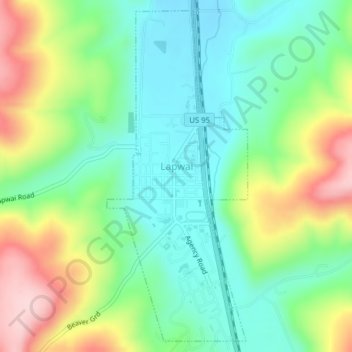
Name: Lapwai topographic map, elevation, terrain.
Location: Lapwai, Nez Perce County, Idaho, 83540, United States (46.39139 -116.81236 46.41676 -116.79671)
Average elevation: 1,194 ft
Minimum elevation: 909 ft
Maximum elevation: 1,736 ft
Nez Perce County trails, hiking, mountain biking, running and outdoor activities
Make a donation
Gear up for your next adventure:
As an Amazon Associate, this site earns from qualifying purchases at no extra cost to you.
Other topographic maps
Click on a map to view its topography, its elevation and its terrain.