Geolocate

Tooting topographic map

Click on the map to display elevation.

About this map

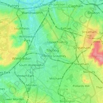
Name: Tooting topographic map, elevation, terrain.

Location: Tooting, London, Greater London, England, SW17 0TF, United Kingdom (51.38782 -0.20797 51.46782 -0.12797)

Average elevation: 98 ft

Minimum elevation: 0 ft

Maximum elevation: 328 ft

Other topographic maps

Click on a map to view its topography, its elevation and its terrain.

London

United Kingdom > England > London

Average elevation: 253 ft

Pool River

United Kingdom > England > London

Average elevation: 118 ft

Hackney Marshes

United Kingdom > England > London

Average elevation: 33 ft

Harmondsworth Moor

United Kingdom > England > London

Average elevation: 85 ft

Hampstead Heath

United Kingdom > England > London

Average elevation: 308 ft

London

United Kingdom > England > London

Average elevation: 69 ft

Kensington Gardens

United Kingdom > England > London

Average elevation: 82 ft

Hampstead No. 1 Pond

United Kingdom > England > London

Average elevation: 266 ft

Plumstead Common

United Kingdom > England > London

Average elevation: 144 ft

Soho Square

United Kingdom > England > London > Islington

Average elevation: 92 ft

Falcon Park

United Kingdom > England > London

Average elevation: 36 ft

Castlewood

United Kingdom > England > London

Average elevation: 226 ft

Gear up for your next adventure:

🥤Water Filter Bottle - All‑in‑one filter bottle for safe hydration
🌄Hiking Binoculars - Compact binoculars for scenic views and trail spotting
🥇GPS Hiking Watch - Multi‑sport GPS watch with navigation and trail tracking
👟Men's Trail Runners - Lightweight footwear for fast-paced exploration and light hiking
🪶Multi‑Purpose Knife - Useful blade for camp and trail

As an Amazon Associate, this site earns from qualifying purchases at no extra cost to you.