
Chíquiza topographic map
Interactive map
Click on the map to display elevation.
About this map
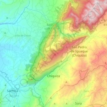
Name: Chíquiza topographic map, elevation, terrain.
Location: Chíquiza, Centro, Boyacá, Colombia (5.56160 -73.51457 5.71144 -73.37660)
Average elevation: 8,789 ft
Minimum elevation: 6,798 ft
Maximum elevation: 12,526 ft
Other topographic maps
Click on a map to view its topography, its elevation and its terrain.
Villa de Leyva
Villa de Leyva, Ricaurte, Boyacá, Colombia
Average elevation: 7,927 ft
San José de Pare
Colombia > Boyacá > San José de Pare
San José de Pare, Ricaurte, Boyacá, 154460, Colombia
Average elevation: 5,436 ft
Puerto Boyacá
Colombia > Boyacá > Puerto Boyacá
Puerto Boyacá, Occidente, Boyacá, Colombia
Average elevation: 846 ft
Villa de Leyva
Colombia > Boyacá > Villa de Leyva
Villa de Leyva, Boyacá, 15401, Colombia
Average elevation: 8,770 ft