Geolocate

Strafford topographic map

Interactive map

Click on the map to display elevation.

Strafford

According to the United States Census Bureau, the city has a total area of 2.63 square miles (6.81 km2), all land. USGS Department of the Interior Original Survey 1838 and USGS Topographical Maps show the town along the White River Road that became the Telegraph Road to Saint Louis.

Wikipedia (CC-BY-SA 3.0)

About this map

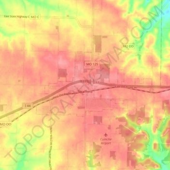
Name: Strafford topographic map, elevation, terrain.

Location: Strafford, Greene County, Missouri, 65757, United States (37.24990 -93.17208 37.29222 -93.08138)

Average elevation: 1,434 ft

Minimum elevation: 1,250 ft

Maximum elevation: 1,512 ft

Greene County trails, hiking, mountain biking, running and outdoor activities

Other topographic maps

Click on a map to view its topography, its elevation and its terrain.

James River

United States > Missouri > Greene County

Average elevation: 1,266 ft

Fellows Lake

United States > Missouri > Greene County

Average elevation: 1,339 ft

Mascot

United States > Missouri > Greene County

Average elevation: 1,234 ft

Ebenezer

United States > Missouri > Greene County

Average elevation: 1,247 ft

Bois D'Arc

United States > Missouri > Greene County

Average elevation: 1,217 ft

Sacville

United States > Missouri > Greene County

Average elevation: 1,093 ft

Turners

United States > Missouri > Greene County

Average elevation: 1,286 ft

Wilsons Creek

United States > Missouri > Greene County > Springfield

Average elevation: 1,247 ft

Republic

United States > Missouri > Greene County > Republic > Republic

Average elevation: 1,270 ft