Geolocate

Wimborne topographic map

Click on the map to display elevation.

Wimborne

Wimborne is a hamlet in southern Alberta, Canada within Kneehill County. It is located approximately 58 km (36 mi) southeast of Red Deer. It has an elevation of 975 m (3,199 ft).

Wikipedia (CC-BY-SA 3.0)

About this map

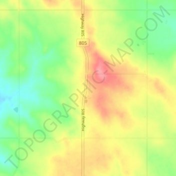
Name: Wimborne topographic map, elevation, terrain.

Location: Wimborne, Kneehill County, Alberta, Canada (51.84410 -113.61341 51.88410 -113.57341)

Average elevation: 3,156 ft

Minimum elevation: 3,028 ft

Maximum elevation: 3,301 ft

Gear up for your next adventure:

🎒Day Hiking Backpack - Lightweight backpack perfect for day trips and outdoor adventures
🔌Solar Panel Charger - Charge gear sustainably outdoors
🧺Microfiber Travel Towels - Compact and fast-drying towels for trail use
🎒Outdoor Daypacks - Lightweight backpacks designed for carrying maps and essential gear
🔥Plasma Lighters - Windproof lighters that work in any weather condition

As an Amazon Associate, this site earns from qualifying purchases at no extra cost to you.