Geolocate

Chutsenkha topographic map

Click on the map to display elevation.

About this map

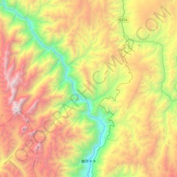
Name: Chutsenkha topographic map, elevation, terrain.

Location: Chutsenkha, Markam County, Chamdo City, Tibet, China (29.06258 98.39146 29.37013 98.74487)

Average elevation: 13,261 ft

Minimum elevation: 7,536 ft

Maximum elevation: 20,479 ft

Other topographic maps

Click on a map to view its topography, its elevation and its terrain.

Chongqing

China > Tibet > Markam County

Average elevation: 12,585 ft

Gear up for your next adventure:

🎒Trekking Poles - Sturdy poles for balance and stability on rough terrain
Camping Coffee Makers - Enjoy premium coffee at the summit or campsite
🧣Merino Neck Gaiters - Multi-functional headwear for wind and sun protection
🥤Water Filter Bottle - All‑in‑one filter bottle for safe hydration
🛠️Outdoor Gear Repair Kit - Essential tools to fix gear on the trail

As an Amazon Associate, this site earns from qualifying purchases at no extra cost to you.