Geolocate

Chongqing topographic map

Click on the map to display elevation.

About this map

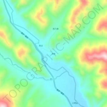
Name: Chongqing topographic map, elevation, terrain.

Location: Chongqing, Markam County, Chamdo City, Tibet, China (29.48868 98.59987 29.52868 98.63987)

Average elevation: 12,585 ft

Minimum elevation: 12,123 ft

Maximum elevation: 13,599 ft

Other topographic maps

Click on a map to view its topography, its elevation and its terrain.

Chutsenkha

China > Tibet > Markam County

Average elevation: 13,261 ft

Gear up for your next adventure:

🚁Photography Drones - Capture stunning aerial views of landforms and topography
🦟Ultrasonic Repellers - Create a bug-free zone at your camp or rest stop
🎒Hydration Pack - Hands‑free water reservoir for long hikes
🌡️Portable Weather Meter - Track weather conditions on the trail
🧢Sun Protection Hats - Wide-brimmed and UPF-rated hats for high-altitude sun safety

As an Amazon Associate, this site earns from qualifying purchases at no extra cost to you.