Geolocate

Cornerville topographic map

Click on the map to display elevation.

About this map

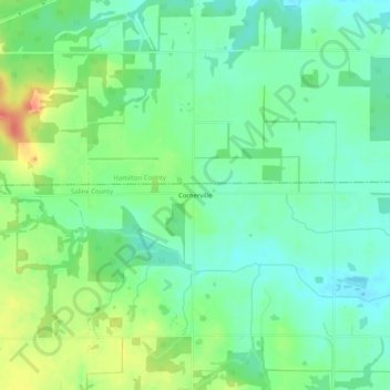
Name: Cornerville topographic map, elevation, terrain.

Location: Cornerville, Saline County, Illinois, United States (37.88699 -88.64339 37.92699 -88.60339)

Average elevation: 466 ft

Minimum elevation: 410 ft

Maximum elevation: 568 ft

Saline County trails, hiking, mountain biking, running and outdoor activities

Other topographic maps

Click on a map to view its topography, its elevation and its terrain.

Carrier Mills

United States > Illinois > Saline County

Average elevation: 404 ft

Muddy

United States > Illinois > Saline County

Average elevation: 364 ft

Stonefort

United States > Illinois > Saline County

Average elevation: 433 ft

Raleigh

United States > Illinois > Saline County

Average elevation: 423 ft

Galatia

United States > Illinois > Saline County

Average elevation: 423 ft

Eldorado

United States > Illinois > Saline County

Average elevation: 410 ft

Gear up for your next adventure:

🛶Inflatable Kayak - Portable kayak for rivers, lakes, and expeditions
🔋Solar Power Banks - Keep your GPS and phone charged in remote wilderness areas
🧷Carabiner Set - Durable clips for gear attachment
🧴Hand Sanitizer - Keep hands clean while hiking
👟Men's Trail Runners - Lightweight footwear for fast-paced exploration and light hiking

As an Amazon Associate, this site earns from qualifying purchases at no extra cost to you.