
Galatia topographic map
Click on the map to display elevation.
About this map
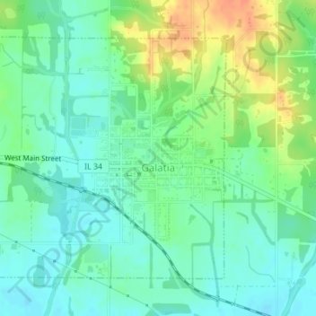
Name: Galatia topographic map, elevation, terrain.
Location: Galatia, Saline County, Illinois, 62935, United States (37.83108 -88.62768 37.85179 -88.60179)
Average elevation: 423 ft
Minimum elevation: 377 ft
Maximum elevation: 512 ft
Saline County trails, hiking, mountain biking, running and outdoor activities
Other topographic maps
Click on a map to view its topography, its elevation and its terrain.
Harrisburg
United States > Illinois > Saline County > Harrisburg
Harrisburg is located at 37°44′2″N 88°32′45″W / 37.73389°N 88.54583°W / 37.73389; -88.54583 (37.733765, −88.545873). According to the 2010 census, Harrisburg has a total area of 6.759 square miles (17.51 km2), of which 6.55 square miles (16.96 km2) (or 96.91%) is land and 0.209 square…
Average elevation: 377 ft