
Make a donation
Gear up for your next adventure:
As an Amazon Associate, this site earns from qualifying purchases at no extra cost to you.
Hope Island topographic map
Click on the map to display elevation.
Make a donation
Gear up for your next adventure:
As an Amazon Associate, this site earns from qualifying purchases at no extra cost to you.
About this map
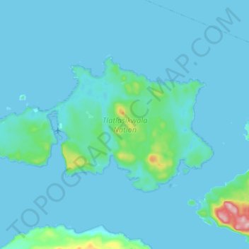
Name: Hope Island topographic map, elevation, terrain.
Average elevation: 52 ft
Minimum elevation: -3 ft
Maximum elevation: 745 ft
Make a donation
Gear up for your next adventure:
As an Amazon Associate, this site earns from qualifying purchases at no extra cost to you.
Other topographic maps
Click on a map to view its topography, its elevation and its terrain.
Schloss Island
Canada > British Columbia > Regional District of Mount Waddington > Area B (Quatsino Sound/Cape Scott)
Average elevation: 69 ft
William Lake
Canada > British Columbia > Regional District of Mount Waddington > Area B (Quatsino Sound/Cape Scott)
Average elevation: 518 ft
Holberg
Canada > British Columbia > Regional District of Mount Waddington > Area B (Quatsino Sound/Cape Scott) > Holberg
Average elevation: 492 ft
Mount Lemon
Canada > British Columbia > Regional District of Mount Waddington > Area B (Quatsino Sound/Cape Scott)
Average elevation: 407 ft
Make a donation
Gear up for your next adventure:
As an Amazon Associate, this site earns from qualifying purchases at no extra cost to you.