
Make a donation
Gear up for your next adventure:
As an Amazon Associate, this site earns from qualifying purchases at no extra cost to you.
Kidron topographic map
Click on the map to display elevation.
Make a donation
Gear up for your next adventure:
As an Amazon Associate, this site earns from qualifying purchases at no extra cost to you.
About this map
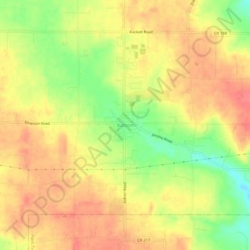
Name: Kidron topographic map, elevation, terrain.
Location: Kidron, Wayne County, Ohio, 44636, United States (40.72089 -81.76485 40.76089 -81.72485)
Average elevation: 1,178 ft
Minimum elevation: 1,037 ft
Maximum elevation: 1,266 ft
Wayne County trails, hiking, mountain biking, running and outdoor activities
Make a donation
Gear up for your next adventure:
As an Amazon Associate, this site earns from qualifying purchases at no extra cost to you.
Other topographic maps
Click on a map to view its topography, its elevation and its terrain.
Doylestown
United States > Ohio > Wayne County
A handful of small streams begin at springs on the slopes of the hill and flow from the higher elevations into larger creeks surrounding the village. Silver Creek drains the town on the east, Mill Creek on the north and west, while Chippewa Creek drains the south side and collects both Mill and Silver Creeks.…
Average elevation: 1,158 ft
Make a donation
Gear up for your next adventure:
As an Amazon Associate, this site earns from qualifying purchases at no extra cost to you.
Make a donation
Gear up for your next adventure:
As an Amazon Associate, this site earns from qualifying purchases at no extra cost to you.