Geolocate

Ithaca topographic map

Click on the map to display elevation.

About this map

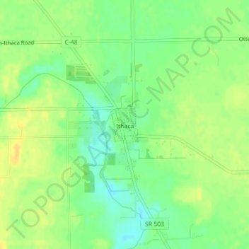
Name: Ithaca topographic map, elevation, terrain.

Location: Ithaca, Darke County, Ohio, United States (39.93563 -84.55521 39.93922 -84.55150)

Average elevation: 1,043 ft

Minimum elevation: 1,001 ft

Maximum elevation: 1,079 ft

Darke County trails, hiking, mountain biking, running and outdoor activities

Other topographic maps

Click on a map to view its topography, its elevation and its terrain.

Union Corners

United States > Ohio > Darke County

Average elevation: 1,010 ft

Webster

United States > Ohio > Darke County

Average elevation: 991 ft

Horatio

United States > Ohio > Darke County

Average elevation: 1,010 ft

Abbottsville

United States > Ohio > Darke County

Average elevation: 1,050 ft

Hill Grove

United States > Ohio > Darke County

Average elevation: 1,073 ft

Delisle

United States > Ohio > Darke County

Average elevation: 1,053 ft

Gear up for your next adventure:

🚪Portable Camp Chair - Foldable chair for comfort at camp
🥤Water Filter Bottle - All‑in‑one filter bottle for safe hydration
🎒Hydration Pack - Hands‑free water reservoir for long hikes
🧦Hiking Socks - Comfortable socks to prevent blisters on long hikes
🧭Map Reading Tools - Tools and kits for map navigation

As an Amazon Associate, this site earns from qualifying purchases at no extra cost to you.