
Make a donation
Gear up for your next adventure:
As an Amazon Associate, this site earns from qualifying purchases at no extra cost to you.
Fiss topographic map
Click on the map to display elevation.
Make a donation
Gear up for your next adventure:
As an Amazon Associate, this site earns from qualifying purchases at no extra cost to you.
About this map
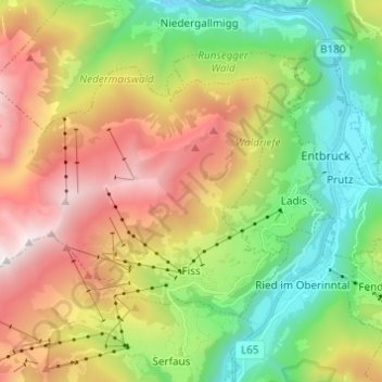
Name: Fiss topographic map, elevation, terrain.
Location: Fiss, Bezirk Landeck, Tyrol, 6533, Austria (47.04717 10.52583 47.10162 10.64791)
Average elevation: 5,180 ft
Minimum elevation: 2,713 ft
Maximum elevation: 8,776 ft
Make a donation
Gear up for your next adventure:
As an Amazon Associate, this site earns from qualifying purchases at no extra cost to you.
Other topographic maps
Click on a map to view its topography, its elevation and its terrain.
Make a donation
Gear up for your next adventure:
As an Amazon Associate, this site earns from qualifying purchases at no extra cost to you.
Make a donation
Gear up for your next adventure:
As an Amazon Associate, this site earns from qualifying purchases at no extra cost to you.
Pettneu am Arlberg
Austria > Tyrol > Bezirk Landeck > Gemeinde Pettneu am Arlberg > Pettneu am Arlberg
Average elevation: 5,295 ft
Perjen
Austria > Tyrol > Bezirk Landeck > Stadt Landeck > Landeck > Perjen
Average elevation: 3,576 ft