
Make a donation
Gear up for your next adventure:
As an Amazon Associate, this site earns from qualifying purchases at no extra cost to you.
Brasília topographic map
Click on the map to display elevation.
Make a donation
Gear up for your next adventure:
As an Amazon Associate, this site earns from qualifying purchases at no extra cost to you.
Brasília
The city sits at an elevation of 1,000 metres (3,300 ft) and more, high on the Brazilian Highlands in the country's center-western region. Paranoá Lake, a large artificial lake, was built to increase the amount of water available and to maintain the region's humidity. It has a marina, and hosts wakeboarders and windsurfers. Diving can also be practiced and one of the main attractions is Vila Amaury, an old village submerged in the lake. This is where the first construction workers of Brasília used to live.
Make a donation
Gear up for your next adventure:
As an Amazon Associate, this site earns from qualifying purchases at no extra cost to you.
About this map
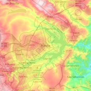
Name: Brasília topographic map, elevation, terrain.
Average elevation: 3,556 ft
Minimum elevation: 2,838 ft
Maximum elevation: 4,278 ft
Make a donation
Gear up for your next adventure:
As an Amazon Associate, this site earns from qualifying purchases at no extra cost to you.
Other topographic maps
Click on a map to view its topography, its elevation and its terrain.
Lago Norte
Brazil > Federal District > Região Integrada de Desenvolvimento do Distrito Federal e Entorno
Average elevation: 3,533 ft
Sobradinho II
Brazil > Federal District > Região Integrada de Desenvolvimento do Distrito Federal e Entorno
Average elevation: 3,235 ft
SIA
Brazil > Federal District > Região Integrada de Desenvolvimento do Distrito Federal e Entorno
Average elevation: 3,635 ft
Taguatinga
Brazil > Federal District > Região Integrada de Desenvolvimento do Distrito Federal e Entorno
Average elevation: 3,875 ft
Make a donation
Gear up for your next adventure:
As an Amazon Associate, this site earns from qualifying purchases at no extra cost to you.
Vicente Pires
Brazil > Federal District > Região Integrada de Desenvolvimento do Distrito Federal e Entorno
Average elevation: 3,684 ft
Guará
Brazil > Federal District > Região Integrada de Desenvolvimento do Distrito Federal e Entorno
Average elevation: 3,566 ft
Jardim Botânico
Brazil > Federal District > Região Integrada de Desenvolvimento do Distrito Federal e Entorno
Average elevation: 3,360 ft
Lago Sul
Brazil > Federal District > Região Integrada de Desenvolvimento do Distrito Federal e Entorno
Average elevation: 3,530 ft
Make a donation
Gear up for your next adventure:
As an Amazon Associate, this site earns from qualifying purchases at no extra cost to you.
Ceilândia
Brazil > Federal District > Região Integrada de Desenvolvimento do Distrito Federal e Entorno
Average elevation: 3,750 ft