
Lago Norte topographic map
Click on the map to display elevation.
About this map
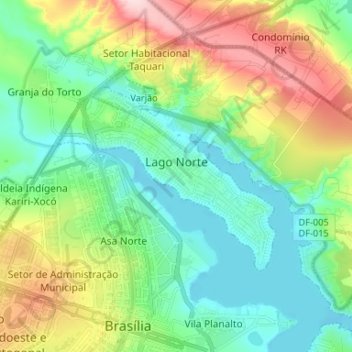
Name: Lago Norte topographic map, elevation, terrain.
Average elevation: 3,533 ft
Minimum elevation: 3,271 ft
Maximum elevation: 4,114 ft
Other topographic maps
Click on a map to view its topography, its elevation and its terrain.
Brasília
Brazil > Federal District > Região Integrada de Desenvolvimento do Distrito Federal e Entorno
The city sits at an elevation of 1,000 metres (3,300 ft) and more, high on the Brazilian Highlands in the country's center-western region. Paranoá Lake, a large artificial lake, was built to increase the amount of water available and to maintain the region's humidity. It has a marina, and hosts wakeboarders…
Average elevation: 3,556 ft
Condominio Verde Perto
Brazil > Federal District > Região Integrada de Desenvolvimento do Distrito Federal e Entorno > Guará
Average elevation: 3,606 ft