
Cave City topographic map
Interactive map
Click on the map to display elevation.
About this map
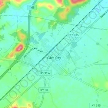
Name: Cave City topographic map, elevation, terrain.
Location: Cave City, Barren County, Kentucky, United States (37.12041 -85.99774 37.15645 -85.93421)
Average elevation: 679 ft
Minimum elevation: 604 ft
Maximum elevation: 951 ft
Other topographic maps
Click on a map to view its topography, its elevation and its terrain.
Eighty Eight
United States > Kentucky > Barren County
Eighty Eight, Barren County, Kentucky, United States
Average elevation: 791 ft
Etoile
United States > Kentucky > Barren County
Etoile, Barren County, Kentucky, 42131, United States
Average elevation: 807 ft
Hiseville
United States > Kentucky > Barren County
Hiseville, Barren County, Kentucky, 42152, United States
Average elevation: 725 ft
Rocky Hill
United States > Kentucky > Barren County
Rocky Hill, Barren County, Kentucky, United States
Average elevation: 676 ft
Austin
United States > Kentucky > Barren County
Austin, Barren County, Kentucky, 42123, United States
Average elevation: 709 ft
Park City
United States > Kentucky > Barren County
Park City, Barren County, Kentucky, United States
Average elevation: 659 ft
Glasgow
United States > Kentucky > Barren County > Glasgow > Glasgow
Glasgow, Barren County, Kentucky, 42142, United States
Average elevation: 755 ft
Lucas
United States > Kentucky > Barren County > Lucas
Lucas, Barren County, Kentucky, 42156, United States
Average elevation: 646 ft
Glasgow
United States > Kentucky > Barren County
Glasgow, Barren County, Kentucky, United States
Average elevation: 755 ft