Geolocate

Caudete topographic map

Click on the map to display elevation.

About this map
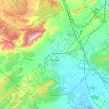
Name: Caudete topographic map, elevation, terrain.

Location: Caudete, Albacete, Castile-La Mancha, 02660, Spain (38.65507 -1.11967 38.77479 -0.91579)

Average elevation: 2,188 ft

Minimum elevation: 1,601 ft

Maximum elevation: 3,750 ft

Other topographic maps

Click on a map to view its topography, its elevation and its terrain.

Huelga del Escobar

Spain > Castile-La Mancha > Uña

Average elevation: 4,052 ft

Rio Júcar

Spain > Castile-La Mancha > Cuenca

Average elevation: 3,133 ft

El Encaño

Spain > Castile-La Mancha > Buenache de Alarcón

Average elevation: 2,874 ft

La Sotama

Spain > Castile-La Mancha > Sigüenza > Riba de Santiuste

Average elevation: 3,219 ft

El Alto

Spain > Castile-La Mancha > Sigüenza

Average elevation: 3,704 ft

Aragosa

Spain > Castile-La Mancha > Aragosa

Average elevation: 3,291 ft

El Cobato

Spain > Castile-La Mancha > Cuenca > Huete

Average elevation: 3,127 ft

Gear up for your next adventure:

🕶️Glacier Sunglasses - Side shields to protect eyes from high-altitude snow glare
⛺Backpacking Tent - Lightweight and durable tent for multi‑day hikes
🔥Camping Stove - Portable stove for camping and backcountry cooking
🔥Fast-Boil Camping Stoves - Efficient cooking systems for quick trail meals
📚Navigation Handbooks - Master the art of reading topographic maps and using a compass

As an Amazon Associate, this site earns from qualifying purchases at no extra cost to you.