
Mykines topographic map
Interactive map
Click on the map to display elevation.
About this map
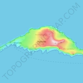
Name: Mykines topographic map, elevation, terrain.
Location: Mykines, Vágar region, 388, Faroe Islands (62.09197 -7.66482 62.11701 -7.52789)
Average elevation: 141 ft
Minimum elevation: -125 ft
Maximum elevation: 1,850 ft
Other topographic maps
Click on a map to view its topography, its elevation and its terrain.
Gásadalur
Gásadalur, Vágar region, 387, Faroe Islands
Average elevation: 433 ft
Tippi
Faroe Islands > Vágar region > Gásadalur
Tippi, Gásadalur, Vágar region, 387, Faroe Islands
Average elevation: 561 ft