
Vágar topographic map
Interactive map
Click on the map to display elevation.
About this map
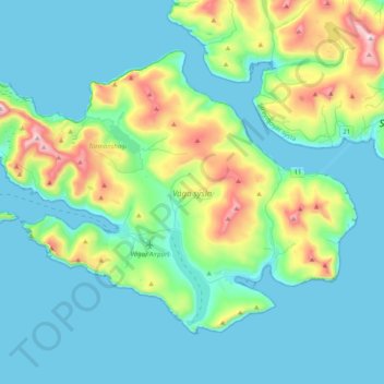
Name: Vágar topographic map, elevation, terrain.
Location: Vágar, Vágar region, Faroe Islands (62.02008 -7.46502 62.15971 -7.06015)
Average elevation: 463 ft
Minimum elevation: -3 ft
Maximum elevation: 2,421 ft
Other topographic maps
Click on a map to view its topography, its elevation and its terrain.
Gásadalur
Gásadalur, Vágar region, 387, Faroe Islands
Average elevation: 433 ft
Tippi
Faroe Islands > Vágar region > Gásadalur
Tippi, Gásadalur, Vágar region, 387, Faroe Islands
Average elevation: 561 ft
Mykines
Mykines, Vágar region, 388, Faroe Islands
Average elevation: 141 ft