Geolocate

Pleasant Ridge topographic map

Click on the map to display elevation.

About this map

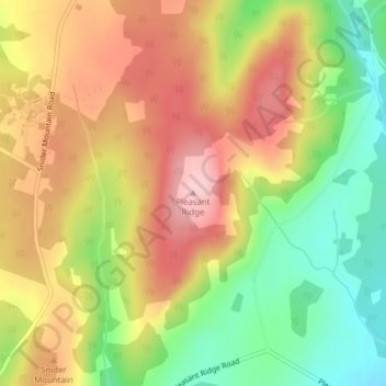
Name: Pleasant Ridge topographic map, elevation, terrain.

Location: Pleasant Ridge, Studholm Parish, Kings County, New Brunswick, E5P 4B4, Canada (45.82673 -65.62081 45.82683 -65.62071)

Average elevation: 515 ft

Minimum elevation: 177 ft

Maximum elevation: 827 ft

Other topographic maps

Click on a map to view its topography, its elevation and its terrain.

Town of Sussex

Canada > New Brunswick > Kings County

Average elevation: 197 ft

Town of Rothesay

Canada > New Brunswick > Kings County

Average elevation: 167 ft

Town of Quispamsis

Canada > New Brunswick > Kings County

Average elevation: 174 ft

Havelock Parish

Canada > New Brunswick > Kings County

Average elevation: 295 ft

Town of Rothesay

Canada > New Brunswick > Kings County

Average elevation: 177 ft

Town of Sussex

Canada > New Brunswick > Kings County

Average elevation: 194 ft

Gear up for your next adventure:

🔦Powerful Headlamps - Ultra-bright hands-free lighting for night navigation
🖼️Topo Map Wall Art - Decorative topographic prints of famous peaks and regions
🔪Outdoor Multitools - Essential survival tools for gear repair and field use
🧤Hiking Gloves - Protective gloves for rugged trails
🧯Portable Fire Pit - Compact fire pit for camping spots

As an Amazon Associate, this site earns from qualifying purchases at no extra cost to you.