
Thank you for supporting this site ❤️
Make a donation
Make a donation
Gear up for your next adventure:
As an Amazon Associate, this site earns from qualifying purchases at no extra cost to you.
Malekhu topographic map
Click on the map to display elevation.
Thank you for supporting this site ❤️
Make a donation
Make a donation
Gear up for your next adventure:
As an Amazon Associate, this site earns from qualifying purchases at no extra cost to you.
About this map
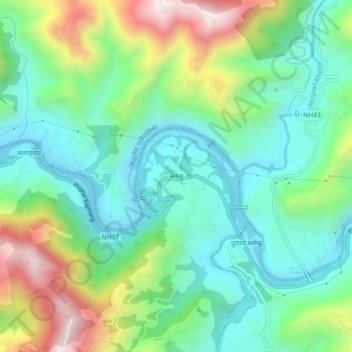
Name: Malekhu topographic map, elevation, terrain.
Location: Malekhu, Benighat Rorang, Dhading, Bagmati Pradesh, Nepal (27.79371 84.80724 27.83371 84.84724)
Average elevation: 1,804 ft
Minimum elevation: 1,093 ft
Maximum elevation: 3,373 ft
Thank you for supporting this site ❤️
Make a donation
Make a donation
Gear up for your next adventure:
As an Amazon Associate, this site earns from qualifying purchases at no extra cost to you.