Geolocate

Winchester topographic map

Click on the map to display elevation.

About this map

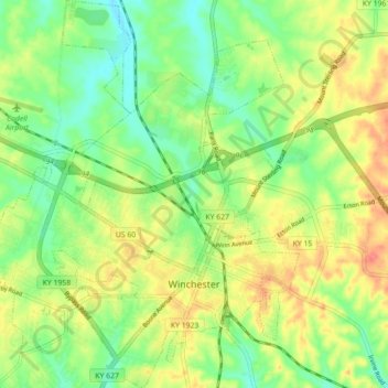
Name: Winchester topographic map, elevation, terrain.

Location: Winchester, Clark County, Kentucky, United States (37.97144 -84.22872 38.04113 -84.15570)

Average elevation: 971 ft

Minimum elevation: 883 ft

Maximum elevation: 1,076 ft

Clark County trails, hiking, mountain biking, running and outdoor activities

Other topographic maps

Click on a map to view its topography, its elevation and its terrain.

Trapp

United States > Kentucky > Clark County

Average elevation: 774 ft

Hampton Manor

United States > Kentucky > Clark County > Winchester

Average elevation: 974 ft

Hampton Manor

United States > Kentucky > Clark County > Winchester

Average elevation: 974 ft

Ruckerville

United States > Kentucky > Clark County

Average elevation: 925 ft

Gear up for your next adventure:

🛰️Handheld GPS Units - Professional satellite navigators for precise backcountry mapping
🎒Outdoor Daypacks - Lightweight backpacks designed for carrying maps and essential gear
🧭Orienteering Set - Complete compass and map reading kit
📻Weather Alert Radios - Stay informed of storm risks while off-the-grid
🚁Photography Drones - Capture stunning aerial views of landforms and topography

As an Amazon Associate, this site earns from qualifying purchases at no extra cost to you.