Geolocate

Ruckerville topographic map

Click on the map to display elevation.

About this map

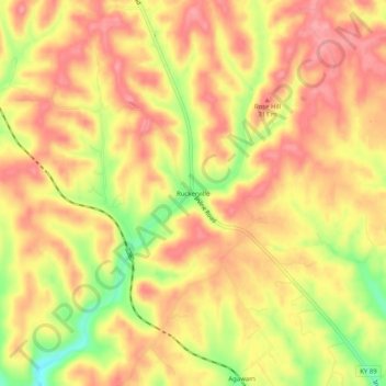
Name: Ruckerville topographic map, elevation, terrain.

Location: Ruckerville, Clark County, Kentucky, United States (37.91369 -84.11437 37.95369 -84.07437)

Average elevation: 925 ft

Minimum elevation: 719 ft

Maximum elevation: 1,033 ft

Clark County trails, hiking, mountain biking, running and outdoor activities

Other topographic maps

Click on a map to view its topography, its elevation and its terrain.

Winchester

United States > Kentucky > Clark County

Average elevation: 971 ft

Winchester

United States > Kentucky > Clark County

Average elevation: 971 ft

Gear up for your next adventure:

🪶Camping Sleeping Pad - Comfortable sleeping pad for backpacking
🔪Outdoor Multitools - Essential survival tools for gear repair and field use
📶Vehicle Signal Boosters - Improve reception in rural areas while driving to trailheads
📌Outdoor GPS Map App - Apps and devices for digital topographic navigation
🦟Ultrasonic Repellers - Create a bug-free zone at your camp or rest stop

As an Amazon Associate, this site earns from qualifying purchases at no extra cost to you.