Geolocate

Nanaimo topographic map

Click on the map to display elevation.

About this map

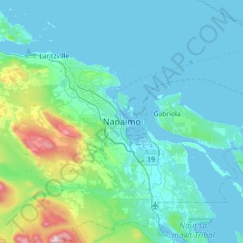
Name: Nanaimo topographic map, elevation, terrain.

Location: Nanaimo, British Columbia, V9R 5C7, Canada (49.00388 -124.09812 49.32388 -123.77812)

Average elevation: 466 ft

Minimum elevation: -3 ft

Maximum elevation: 4,026 ft

Gear up for your next adventure:

🧣Hiking Neck Gaiter - Multi‑use neck protection for outdoor weather
🧥Men's Rain Shells - Premium waterproof and breathable jackets for mountain weather
📻Weather Alert Radios - Stay informed of storm risks while off-the-grid
Backpacking Tent - Lightweight and durable tent for multi‑day hikes
🎁Geography Themed Gifts - Unique gift ideas for map lovers and geography enthusiasts

As an Amazon Associate, this site earns from qualifying purchases at no extra cost to you.