
Make a donation
Gear up for your next adventure:
As an Amazon Associate, this site earns from qualifying purchases at no extra cost to you.
Sperlsiek topographic map
Click on the map to display elevation.
Make a donation
Gear up for your next adventure:
As an Amazon Associate, this site earns from qualifying purchases at no extra cost to you.
About this map
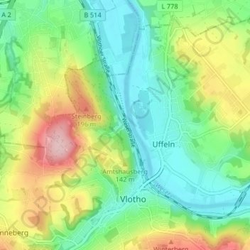
Name: Sperlsiek topographic map, elevation, terrain.
Average elevation: 361 ft
Minimum elevation: 138 ft
Maximum elevation: 781 ft
Make a donation
Gear up for your next adventure:
As an Amazon Associate, this site earns from qualifying purchases at no extra cost to you.
Other topographic maps
Click on a map to view its topography, its elevation and its terrain.
Uffeln
Deutschland > Nordrhein-Westfalen > Kreis Herford > Vlotho
Uffeln liegt als einziges Gebiet des Kreises Herford östlich der Weser und gehört damit geografisch nicht zum Ravensberger Land. Ein Großteil des Gebietes besteht aus dem bis zu 170 m hohen Höhenrücken Buhn. Dieser Hügel fällt an seiner südöstlichen steil ab. Sein Name ist gleichbedeutend mit…
Average elevation: 341 ft
Make a donation
Gear up for your next adventure:
As an Amazon Associate, this site earns from qualifying purchases at no extra cost to you.