Geolocate

Rizal topographic map

Click on the map to display elevation.

About this map

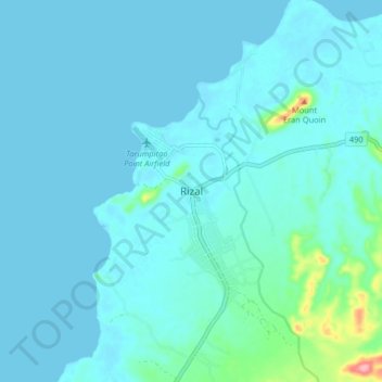
Name: Rizal topographic map, elevation, terrain.

Location: Rizal, Palawan, Mimaropa, 5304, Philippines (8.99410 117.60257 9.07410 117.68257)

Average elevation: 39 ft

Minimum elevation: -3 ft

Maximum elevation: 413 ft

Other topographic maps

Click on a map to view its topography, its elevation and its terrain.

Lio Beach

Philippines > Palawan > El Nido > Villa Libertad

Average elevation: 43 ft

Corong Beach

Philippines > Palawan > El Nido

Average elevation: 164 ft

Iloc Island

Philippines > Palawan > Linapacan

Average elevation: 75 ft

Malcapuya Island

Philippines > Palawan > Culion

Average elevation: 7 ft

Malaroroy Island

Philippines > Palawan > Coron > Bulog

Average elevation: 7 ft

Uson Island

Philippines > Palawan > Coron > Bancuan

Average elevation: 46 ft

Coron Island

Philippines > Palawan > Coron

Average elevation: 121 ft

Balabac Island

Philippines > Palawan

Average elevation: 66 ft

Iguana Island

Philippines > Palawan > Culion

Average elevation: 16 ft

Lake Manguao

Philippines > Palawan

Average elevation: 174 ft

Pamalican Island

Philippines > Palawan > Cuyo

Average elevation: 3 ft

Magsaysay

Philippines > Palawan

Average elevation: 3 ft

Shimizu Island

Philippines > Palawan

Average elevation: 59 ft

Kalayaan

Philippines > Palawan

The islets that comprise the municipality are generally flat. The highest ground elevation is approximately two meters above sea level.

Average elevation: 0 ft

Lagen Island

Philippines > Palawan

Average elevation: 144 ft

Inabuyatan Island

Philippines > Palawan

Average elevation: 10 ft

Coron

Philippines > Palawan

Average elevation: 39 ft

Dicilingan Island

Philippines > Palawan > Busuanga

Average elevation: 3 ft

Horse Island

Philippines > Palawan > Busuanga

Average elevation: 3 ft

Linapacan

Philippines > Palawan

Average elevation: 33 ft

Cagayancillo

Philippines > Palawan

There are neither mountain ranges nor forested areas in the municipality. A hilly portion in the north-eastern part of the main island has a slope of 3-82%. The other areas are flat with the highest elevation around 2 to 3 meters. The majority of the island has a sandy loam soil not enough to support a forest.…

Average elevation: 0 ft

Balabac

Philippines > Palawan

Average elevation: 7 ft

Agutaya

Philippines > Palawan

Average elevation: 0 ft

Gear up for your next adventure:

👖Convertible Hiking Pants - Versatile zip-off pants for changing altitudes and temperatures
📦Gear Storage Bags - Organize and protect outdoor equipment
📚Navigation Handbooks - Master the art of reading topographic maps and using a compass
🏔️Mountain Trail Maps - High‑detail maps for popular peaks
🪶Thermal Camp Blanket - Extra warmth for cold nights

As an Amazon Associate, this site earns from qualifying purchases at no extra cost to you.