
Thank you for supporting this site ❤️
Make a donation
Make a donation
Gear up for your next adventure:
As an Amazon Associate, this site earns from qualifying purchases at no extra cost to you.
Plessisville topographic map
Click on the map to display elevation.
Thank you for supporting this site ❤️
Make a donation
Make a donation
Gear up for your next adventure:
As an Amazon Associate, this site earns from qualifying purchases at no extra cost to you.
About this map
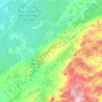
Name: Plessisville topographic map, elevation, terrain.
Location: Plessisville, L'Érable, Centre-du-Québec, Quebec, Canada (46.14818 -71.86972 46.31741 -71.65643)
Average elevation: 558 ft
Minimum elevation: 338 ft
Maximum elevation: 1,430 ft
Thank you for supporting this site ❤️
Make a donation
Make a donation
Gear up for your next adventure:
As an Amazon Associate, this site earns from qualifying purchases at no extra cost to you.