Geolocate

Parede topographic map

Click on the map to display elevation.

About this map

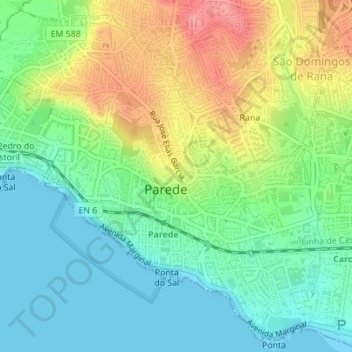
Name: Parede topographic map, elevation, terrain.

Location: Parede, Carcavelos e Parede, Cascais, Lisbon, Portugal (38.68052 -9.37304 38.70605 -9.34086)

Average elevation: 121 ft

Minimum elevation: 0 ft

Maximum elevation: 335 ft

Other topographic maps

Click on a map to view its topography, its elevation and its terrain.

Parque Urbano Outeiro da Vela

Portugal > Lisbon > Cascais

Average elevation: 144 ft

Atrozela

Portugal > Lisbon > Cascais

Average elevation: 397 ft

Biscaia

Portugal > Lisbon > Cascais

Average elevation: 538 ft

Casal da Serra

Portugal > Lisbon > Cascais

Average elevation: 394 ft

São Jorge de Oitavos

Portugal > Lisbon > Cascais

Average elevation: 69 ft

Malveira da Serra

Portugal > Lisbon > Cascais

Average elevation: 594 ft

Gear up for your next adventure:

🥄Camping Utensil Set - Lightweight utensils for outdoor meals
🧯Emergency Survival Kit - All‑in‑one survival essentials for the backcountry
🛰️Handheld GPS Units - Professional satellite navigators for precise backcountry mapping
📷Action Cameras - Rugged cameras to document your journeys across rugged terrain
🧦Merino Wool Socks - Moisture-wicking, blister-preventing socks for long treks

As an Amazon Associate, this site earns from qualifying purchases at no extra cost to you.