Geolocate

Perry topographic map

Click on the map to display elevation.

About this map

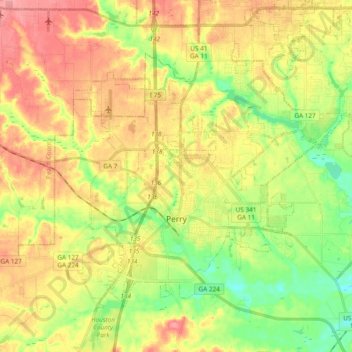
Name: Perry topographic map, elevation, terrain.

Location: Perry, Houston County, Georgia, 31069, United States (32.41637 -83.79762 32.53944 -83.60786)

Average elevation: 364 ft

Minimum elevation: 233 ft

Maximum elevation: 492 ft

Houston County trails, hiking, mountain biking, running and outdoor activities

Other topographic maps

Click on a map to view its topography, its elevation and its terrain.

Elko

United States > Georgia > Houston County

Average elevation: 404 ft

Bonaire

United States > Georgia > Houston County

Average elevation: 328 ft

Bonaire

United States > Georgia > Houston County

Average elevation: 328 ft

Lake Joy

United States > Georgia > Houston County

Average elevation: 344 ft

Elko

United States > Georgia > Houston County

Average elevation: 404 ft

Gear up for your next adventure:

🧦Hiking Socks - Comfortable socks to prevent blisters on long hikes
🦟Ultrasonic Repellers - Create a bug-free zone at your camp or rest stop
🥾Women's Hiking Boots - Top-rated trail boots with ankle support and superior grip
🦶Hiking Gaiters - Keep debris and water out of your boots
📖Nature Tracking Books - Learn to track wildlife and terrain

As an Amazon Associate, this site earns from qualifying purchases at no extra cost to you.