Geolocate

Elko topographic map

Click on the map to display elevation.

About this map

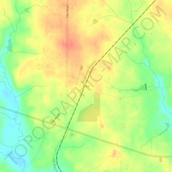
Name: Elko topographic map, elevation, terrain.

Location: Elko, Houston County, Georgia, 31025, United States (32.31121 -83.72617 32.35121 -83.68617)

Average elevation: 404 ft

Minimum elevation: 315 ft

Maximum elevation: 476 ft

Houston County trails, hiking, mountain biking, running and outdoor activities

Other topographic maps

Click on a map to view its topography, its elevation and its terrain.

Warner Robins

United States > Georgia > Houston County

Average elevation: 331 ft

Perry

United States > Georgia > Houston County

Average elevation: 364 ft

Lake Joy

United States > Georgia > Houston County

Average elevation: 344 ft

Perry

United States > Georgia > Houston County

Average elevation: 364 ft

Gear up for your next adventure:

GPS Sports Watch - GPS watch for running, hiking and training
🏔️Mountain Trail Maps - High‑detail maps for popular peaks
🧺Microfiber Travel Towels - Compact and fast-drying towels for trail use
🖼️Topo Map Wall Art - Decorative topographic prints of famous peaks and regions
📱Solar Portable Charger - Solar power bank for charging devices off‑grid

As an Amazon Associate, this site earns from qualifying purchases at no extra cost to you.