Geolocate

Sam Rayburn Reservoir topographic map

Click on the map to display elevation.

About this map

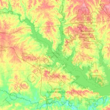
Name: Sam Rayburn Reservoir topographic map, elevation, terrain.

Location: Sam Rayburn Reservoir, Nacogdoches County, Texas, United States (31.06107 -94.56258 31.43544 -93.98216)

Average elevation: 217 ft

Minimum elevation: 82 ft

Maximum elevation: 433 ft

Nacogdoches County trails, hiking, mountain biking, running and outdoor activities

Other topographic maps

Click on a map to view its topography, its elevation and its terrain.

Flower Mountain

United States > Texas > Nacogdoches County

Average elevation: 600 ft

Happy Valley

United States > Texas > Nacogdoches County

Average elevation: 371 ft

Douglass

United States > Texas > Nacogdoches County > Douglass

Average elevation: 341 ft

Linn Flat

United States > Texas > Nacogdoches County > Linn Flat

Average elevation: 413 ft

Sacul

United States > Texas > Nacogdoches County > Sacul

Average elevation: 322 ft

Gear up for your next adventure:

🧭Hiking Compass - Precision compass for reliable navigation in the wilderness
🕶️Glacier Sunglasses - Side shields to protect eyes from high-altitude snow glare
📻Weather Alert Radios - Stay informed of storm risks while off-the-grid
🧴Hand Sanitizer - Keep hands clean while hiking
🔋Solar Power Banks - Keep your GPS and phone charged in remote wilderness areas

As an Amazon Associate, this site earns from qualifying purchases at no extra cost to you.