Geolocate

Mera Peak topographic map

Click on the map to display elevation.

Mera Peak

In September 2017, Hari Budha Magar summited Mera Peak, becoming the first double above-knee amputee to climb a mountain over 6,000m in altitude.

Wikipedia (CC-BY-SA 3.0)

About this map

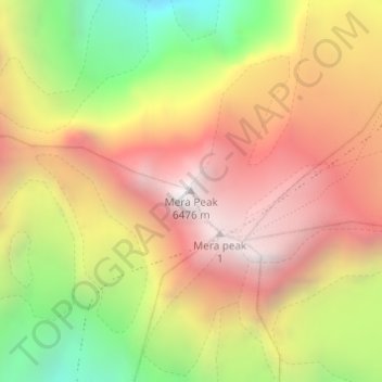
Name: Mera Peak topographic map, elevation, terrain.

Location: Mera Peak, Mahakulung, Solukhumbu, Koshi Province, Nepal (27.70979 86.86861 27.70989 86.86871)

Average elevation: 18,730 ft

Minimum elevation: 15,679 ft

Maximum elevation: 21,161 ft

Other topographic maps

Click on a map to view its topography, its elevation and its terrain.

Sotang

Nepal > Koshi Province > Solukhumbu

Average elevation: 7,129 ft

West Ridge

Nepal > Koshi Province > Solukhumbu

Average elevation: 23,081 ft

Likhupike

Nepal > Koshi Province > Solukhumbu

Average elevation: 9,039 ft

Khumbupasanglahmu-05

Nepal > Koshi Province > Solukhumbu

Average elevation: 17,165 ft

Gear up for your next adventure:

🪶Multi‑Purpose Knife - Useful blade for camp and trail
🧦Hiking Socks - Comfortable socks to prevent blisters on long hikes
☀️Outdoor Sunscreen - High protection sunscreen for outdoor activities
👟Trail Running Shoes - Lightweight shoes for trail runners
🧤Tactile Hiking Gloves - Keep hands warm while operating GPS and smartphone screens

As an Amazon Associate, this site earns from qualifying purchases at no extra cost to you.