Geolocate

Caddo topographic map

Click on the map to display elevation.

About this map

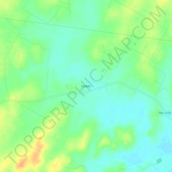
Name: Caddo topographic map, elevation, terrain.

Location: Caddo, Wilson County, Texas, United States (29.27274 -97.92306 29.31274 -97.88306)

Average elevation: 479 ft

Minimum elevation: 430 ft

Maximum elevation: 554 ft

Wilson County trails, hiking, mountain biking, running and outdoor activities

Other topographic maps

Click on a map to view its topography, its elevation and its terrain.

Poth

United States > Texas > Wilson County

Average elevation: 423 ft

Floresville

United States > Texas > Wilson County

Average elevation: 423 ft

Stockdale

United States > Texas > Wilson County

Average elevation: 456 ft

Floresville

United States > Texas > Wilson County

Average elevation: 423 ft

Gear up for your next adventure:

🗺️Topographic Maps - Detailed topo maps for hiking, exploring and outdoor navigation
🥩Freeze-Dried Meals - Nutritious and lightweight food for remote expeditions
🏕️Family Camping Gear - Essentials for group camping trips
🧥Waterproof Jacket for Hiking - Breathable and rugged rain jacket for outdoor excursions
🥘Titanium Cookware - Durable, featherlight pots and pans for backpacking

As an Amazon Associate, this site earns from qualifying purchases at no extra cost to you.