Geolocate

Poth topographic map

Click on the map to display elevation.

About this map

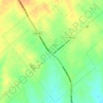
Name: Poth topographic map, elevation, terrain.

Location: Poth, Wilson County, Texas, 78147, United States (29.05358 -98.10164 29.08814 -98.06140)

Average elevation: 423 ft

Minimum elevation: 364 ft

Maximum elevation: 472 ft

Wilson County trails, hiking, mountain biking, running and outdoor activities

Other topographic maps

Click on a map to view its topography, its elevation and its terrain.

Stockdale

United States > Texas > Wilson County

Average elevation: 456 ft

Floresville

United States > Texas > Wilson County

Average elevation: 423 ft

Sutherland Springs

United States > Texas > Wilson County

Average elevation: 440 ft

Caddo

United States > Texas > Wilson County

Average elevation: 479 ft

Gear up for your next adventure:

📚Navigation Handbooks - Master the art of reading topographic maps and using a compass
🧭Compass with Lanyard - Easy‑carry compass for navigation
🪄Magnetic Compass - Accurate compass for navigation
🪶Wildlife Field Guides - Learn animal tracking and species ID
🕶️GPS Smartphone Mount - Secure mount for phone navigation

As an Amazon Associate, this site earns from qualifying purchases at no extra cost to you.