
Make a donation
Gear up for your next adventure:
As an Amazon Associate, this site earns from qualifying purchases at no extra cost to you.
Deering topographic map
Click on the map to display elevation.
Make a donation
Gear up for your next adventure:
As an Amazon Associate, this site earns from qualifying purchases at no extra cost to you.
About this map
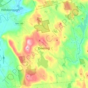
Name: Deering topographic map, elevation, terrain.
Location: Deering, Hillsborough County, New Hampshire, United States (43.03176 -71.91575 43.12427 -71.78562)
Average elevation: 899 ft
Minimum elevation: 541 ft
Maximum elevation: 1,503 ft
Hillsborough County trails, hiking, mountain biking, running and outdoor activities
Make a donation
Gear up for your next adventure:
As an Amazon Associate, this site earns from qualifying purchases at no extra cost to you.
Other topographic maps
Click on a map to view its topography, its elevation and its terrain.
Crotched Mountain
United States > New Hampshire > Hillsborough County > Francestown
Average elevation: 1,375 ft
North Brookline
United States > New Hampshire > Hillsborough County > Brookline
Average elevation: 407 ft
Perham Corner
United States > New Hampshire > Hillsborough County > Lyndeborough
Average elevation: 551 ft
Make a donation
Gear up for your next adventure:
As an Amazon Associate, this site earns from qualifying purchases at no extra cost to you.
West Peterborough
United States > New Hampshire > Hillsborough County > Peterborough
Average elevation: 981 ft
Make a donation
Gear up for your next adventure:
As an Amazon Associate, this site earns from qualifying purchases at no extra cost to you.
East Merrimack
United States > New Hampshire > Hillsborough County > Merrimack
Average elevation: 180 ft
Gibson Four Corners
United States > New Hampshire > Hillsborough County > New Ipswich
Average elevation: 1,076 ft
Make a donation
Gear up for your next adventure:
As an Amazon Associate, this site earns from qualifying purchases at no extra cost to you.
Manchester
United States > New Hampshire > Hillsborough County > Manchester
According to the United States Census Bureau, the city has a total area of 35.0 square miles (90.6 km2), of which 33.1 square miles (85.7 km2) are land and 1.9 square miles (4.8 km2) are water, comprising 5.33% of the city. Manchester is drained by the Merrimack River and its tributaries the Piscataquog River…
Average elevation: 413 ft
Make a donation
Gear up for your next adventure:
As an Amazon Associate, this site earns from qualifying purchases at no extra cost to you.
Cricket Corner
United States > New Hampshire > Hillsborough County > Amherst
Average elevation: 256 ft
Mountain Base
United States > New Hampshire > Hillsborough County > Goffstown
Average elevation: 679 ft